
Silver Fox (S) baseline — The locally proposed AI data center at 13820 Silver Fox Road on a 606-acre site. It’s a ~2-million-square-foot campus (AI lab + four up to 50-ft buildings + FPL substation + two on-site cooling lakes). Early pre-application stage as of March 2026; public hearings likely starting soon. It would directly impact ~200–230 acres of wetlands (about 40% of the site) and protected species (wood storks, sandhill cranes, gopher tortoises, plus a bald eagle nest). The lakes are explicitly for cooling — a classic evaporative setup in Florida’s heat.
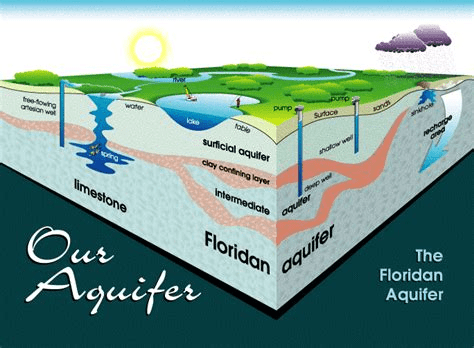
Indiantown sits in the Upper East Coast (UEC) planning area under South Florida Water Management District (SFWMD). You’re on the surficial and Floridan aquifers, tied into the C-44 Canal/St. Lucie River system.
The village’s own water utility currently distributes only 0.4–0.5 million gallons per day (MGD) total and is rushing a new 2.0 MGD reverse-osmosis plant because the 50-year-old system is already at capacity. Officials have been clear: any data center here must be 100% self-sufficient on water and power (developer pays for its own wells/treatment and any new FPL generation).
Hydrology effects scaled to S (1×, 2×, or 3× Silver Fox)
Data-center water use isn’t public for Silver Fox yet (it will need a Consumptive Use Permit from SFWMD with full modeling), but comparable large AI facilities in hot/humid climates use 1–5 MGD consumptive (mostly evaporative loss; ~80% of withdrawn water never returns). Mid-range for a 2M sq ft hyperscale AI build is typically 1–3 MGD. Cooling lakes help with on-site storage but still mean net loss to the atmosphere.
Water consumption & aquifer drawdown
1S = (1) data center
2s = (2) data centers like FPL and 606
3s = (3) data centers like FPL, 606, and soon to be annexed property between 609 and fox brown
MGD – Millions of Gallons a Day
- 1S: 1–3 MGD self-supplied (likely new Floridan wells + RO treatment on-site). That’s 2–6× the village’s entire current daily use and roughly half the capacity of the planned 2 MGD plant. Local aquifer stress would be noticeable within a few miles — possible minor drawdown cones affecting nearby wetlands or ag wells.
- 2S: 2–6 MGD total. This starts to rival or exceed the village’s upgraded system capacity. Cumulative drawdown could lower levels across western Martin County, increasing competition with citrus/agriculture (still the biggest UEC user) and raising permitting hurdles.
- 3S: 3–9+ MGD. Effectively a new “city-scale” demand layered onto a rural aquifer system already projected for growth. In the broader UEC plan, this would accelerate the need for alternative sources (deeper wells, reclaimed, or storage south of Lake O). Drought years (we’re in one now) amplify risk of temporary cutbacks or higher salinity intrusion farther east.
Wetlands & surface-water functions Each Center destroys or alters ~200–230 acres of wetlands (flood storage, nutrient filtration, habitat).
- 1S: Permanent loss of ~40% of one site — reduced flood buffering for the C-44 corridor and downstream Indian River Lagoon.
- 2S: 400–460 acres fragmented across nearby parcels. Connectivity breaks for wildlife corridors; stormwater peaks could increase in the St. Lucie watershed.
- 3S: 600–690 acres. This is a landscape-scale shift in a rural area already near wildlife management zones. Cumulative loss would degrade water-quality treatment that wetlands currently provide for canal flows heading to Lake O releases.
Stormwater, lakes & water quality The on-site cooling lakes act as both cooling ponds and retention. Properly designed they can help, but blowdown (concentrated salts/minerals from evaporative cooling) needs treatment before discharge.
- 1S: Manageable if lakes are lined and monitored with enforceable measures.
- 2–3S: Risk of larger thermal/chemical plumes if not perfectly engineered, plus more impervious surface overall → flashier runoff into the C-44 system during our intense summer rains.
Other hydrology-adjacent notes
- Permitting reality: SFWMD will require detailed modeling of drawdown, wetland mitigation (usually off-site credits at 2–4:1 ratio), and alternatives analysis (e.g., air-cooled or reclaimed-water preference under 2026 state rules). Multiple projects trigger cumulative-impact review.
- Self-sufficiency helps the village utility — but not the regional aquifer or wetlands.
- Positive angle: If developers use advanced reuse/closed-loop tech, actual consumption could drop toward the low end of the range.
Bottom line for Indiantown hydrology: 1S is a big but potentially mitigable addition; 2S starts to reshape local water budgets; 3S would fundamentally alter aquifer and wetland dynamics in western Martin County — especially while we’re still building out the 2 MGD plant and navigating Lake O discharge rules.
Status
From what I can gather on the Silver Fox project (still in that early pre-application phase with the Village of Indiantown and relevant agencies like SFWMD), detailed modeling for aquifer drawdown and a full wetland mitigation plan haven’t been completed or submitted yet as part of the pre-app process.
Here’s the breakdown based on public records and recent reports:
Pre-Application Status
- The pre-app was filed by Silver Fox 606 LLC (a Juno Beach-based entity keeping the end operator anonymous for now). It’s essentially a conceptual proposal outlining the site plan, campus layout, and basic infrastructure (e.g., the four data halls, AI lab, FPL substation, and two on-site cooling lakes).
- No public hearings have been scheduled yet—those are expected soon, where more details would come out.
- SFWMD’s involvement so far is through their standard pre-app review process, which includes site visits and initial environmental scans (via Form 1274 requests for meetings). This helps outline what full studies will be required, but it’s not the stage for submitting comprehensive models or plans.
Environmental Assessments So Far
- SFWMD has done on-site evaluations, identifying ~230 acres of wetlands (about 40% of the 606-acre property) and protected species like wood storks, sandhill cranes, gopher tortoises, and a bald eagle nest. The development would directly impact ~200 acres of those wetlands.
- These are preliminary findings—think wetland delineation (mapping boundaries) and species surveys—to flag issues early. No deeper analysis like hydrological modeling has been referenced in the records.
On Drawdown Modeling and Wetland Mitigation
- Drawdown Modeling: Not mentioned in any pre-app docs or reports. This would involve groundwater simulations (e.g., using MODFLOW or similar tools) to predict how new wells for the data center’s water use (potentially 1–3 MGD from the Floridan aquifer) could lower water tables, affect nearby wells, or worsen saltwater intrusion. SFWMD requires this for the full Consumptive Use Permit (CUP), but pre-app is more about discussing if/when it’s needed.
- Wetland Mitigation: Similarly, no formal plan submitted yet. Pre-app records note the impacts, but mitigation (e.g., off-site restoration credits at a 2:1 or higher ratio, or on-site preservation) comes later in the Environmental Resource Permit (ERP) process. SFWMD will mandate a detailed alternatives analysis and compensatory plan to offset losses, but that’s post-pre-app.
In short, the pre-app is like a scoping exercise—identifying red flags (wetlands, species) without the heavy lifting of models or mitigation blueprints. Those are required for the actual permits, which could take months once the full application drops. If the project advances, expect public docs on SFWMD’s ePermitting portal or Martin County agendas.
- Silver Fox (13820 Silver Fox Road, 606 acres, ~2M sq ft campus with on-site cooling lakes; pre-application stage).
- Two additional centers enabled by the recent FPL voluntary annexation of 5,722.30 acres (approved Jan. 22, 2026, with PUD/light-industrial rezoning and comprehensive-plan amendments for major power generation, utilities, and industrial uses).
- The third (pending annexation) on the parcel bounded east by 609, west by Fox Brown Road, and south by SR 710 — squarely in the new industrial corridor created by the FPL lands.
All three are being required by village officials to be 100% self-sufficient on water and power (no tie-in to the Village’s utility). The FPL annexation/PUD handles land use and electricity infrastructure; water permitting is a completely separate SFWMD process.
Current Baseline (Right Now — No New Data-Center Wells Yet)
- Surficial Aquifer System (SAS) — what most rural private wells tap: Levels are stable to slightly below average after the 2025–2026 dry season (e.g., Martin County monitoring stations in the 17th–25th percentile range per the latest South Florida Environmental Report). No widespread declining trend or restrictions.
- Floridan Aquifer System (FAS) — source for large users: Adequate capacity per the 2021 Upper East Coast Water Supply Plan (next update due late 2026). The Village’s new ~2 MGD reverse-osmosis plant (Floridan source) is for municipal growth only.
- Well activity: Routine ag and domestic permits only. Zero new industrial-scale Floridan production wells for data centers have been permitted yet. No water-shortage orders in western Martin County.
Cumulative Drawdown & Well Activity with All Three Centers
Each facility is expected to need 1.5–4 MGD consumptive use (mostly evaporative loss from cooling lakes — industry standard for this size/heat in Florida). Total new industrial demand: 4.5–12+ MGD layered on top of the Village’s 2 MGD.
Because the three sites sit close together in the same SR 710 / Fox Brown corridor (overlapping drawdown zones), SFWMD will treat them cumulatively in any Consumptive Use Permit (CUP) review.
- Drawdown outlook (based on typical MODFLOW modeling SFWMD requires):
- Single project: Localized cone (mostly a few miles radius, 1–3 ft lowering in dry periods).
- All three together: Overlapping cones → noticeably larger regional effect. Expect 3–7+ ft additional drawdown in the Floridan during peak drought within several miles of the cluster. Some vertical leakage into the shallower SAS is possible, especially in thinner aquifer areas.
- Drought years amplify this (we’re in one now); wet-season recovery would still occur but start from a lower baseline.
- Well activity outlook:
- Multiple new Floridan production wells + monitoring wells across the three sites (dozens total once permitted).
- Rural private wells (mostly SAS) would see no automatic impact, but owners closest to the corridor could experience lower pumping levels or quality changes in extended dry periods.
Risk to Rural Private Wells & Public Protection
SFWMD’s statutory tests (F.S. 373.223) are crystal clear and apply to the combined withdrawals:
- Must be reasonable-beneficial.
- Must not interfere with any presently existing legal use (every private rural well counts).
- Must be in the public interest.
If the required cumulative groundwater modeling shows any measurable harm, the developers (not taxpayers or the Village) must pay for full mitigation — deeper wells, new pumps, alternative supplies, or offsets. This is non-negotiable and has been enforced on similar industrial projects.
Bottom line for your rural wells With one center (Silver Fox alone): Low risk — easily handled by standard CUP conditions. With all three enabled by the FPL/PUD annexations: Medium risk of noticeable localized drawdown effects in dry years for nearby wells. Still technically feasible under current rules and the regional water-supply plan, but permitting will be slower, more expensive, and require stronger mitigation than a single project. The Village’s own 2 MGD plant remains protected because it’s already accounted for.
No full CUP applications or drawdown models have been filed or released yet for any of the three (pre-app / zoning stage only). The moment they are submitted, the modeling maps and predicted contours become public on the SFWMD ePermitting portal — that’s when we’ll have exact numbers instead of ranges.

yes thanks
what about all of Indiantown’s over development will it all further pollute our drinking water and the St Lucie Canal!?
LikeLike